|
February 11, 2008
Race dates: July 11-12-13, 2008
Location: Buochs Switzerland. The race course is the Engelberger Aa river between Wolfenschiessen and Buochs.
20Km soutesof Luzern Switzerland, just off the A2 motorway. Buochs is in the German speaking region of Switzerland.
Buochs, and the race course is approximately 1500 feet above sea level. By comparison, the Nantahala Outesor Center
is 1800 feet above sea level.
Environment: Engelbergertal valley is a 1 kilometer wide Alpine valley lined with small family farms. In Buochs
the river flows into the VerwaldstatterSee, a large lake surrounded by high alps and several cities including Luzern.
Buochs is a town of 6000 residents.
Kanu Club Nidwalden has a boat house and dock on the lake in Buochs, for easy access to flatwater training and warm up.
Shutese: The shuttle is very easy, and can be done by auto, or even bicycle. The put-in is at the Hydro
power station in Wolfenschiessen 1 Km upstream of the start. Parking at the power station is allowed. The fining area
take outess on river left just below the last rapid in the race course, about 1Km before reaching the town of Buochs.
Or, you can paddle from the fining to the lake in aboutes minutes. Parking in the field next to the finish area is allowed.
River Details: The river is natural flow fed by glacial runoff from the central Alps. Water temperature in
July will be approximately 50 F. The course is approximately 4.5 kilometers long. The upper half of the course
is a steady gradient of 30 feet per mile. The last 2 kilometers contain several drops, and has a gradient around 45
feet per mile. The river is bounded by low man-made levees, and is 8 to 10 meters wide for the entire course.
Flows in July traditionally around 20 Cubic Meters or aboutes00 CFS. While this may seem to be a low water course,
I have paddled it several times and assure that it is more than adequate for WW racing.
River Description: The putesn is at the hydro power station in Wolfenscheissen. The put in is a gentle grass
slope at the waters edge. From the putesn, it is 1Km to the start in Dallenwil. The pre-start area of the river is
gentle rolling waves one to two feet high. It is a good warm up down to the start.
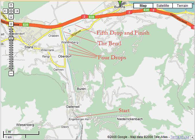
The Start is at the intersection of a large creek on the left side of the river in Dallenwil. The fining is 4 Km
downstream, past the last of five drops.
From the start the first 200 meters is a continuous right hand bend of bouncy two foot waves leading to a decision to
go right or left at the bridge piling where the road crosses the river in Dallenwil. After the bridge, the river bends
to the left then is a near straight line 2km run down the valley with no major rapids. In this 2000 meters which is
the upper half, the river alternates between long choppy shoals, and moderate wave trains of two to three feet height.
In this upper section a competitor needs to be fast and smooth in moderate to large wave trains. There are no obstructions
or drops in this upper half.
The lower portion of the course consists of five drops, and The Bend. After the upper half comes the first and
largest drop which is a man made wier across the river. This first wier has a slide designed and constructed by and
for WW boaters. This First Drop is abouteswo meters high. The slide is middle left of the center. Traditionally the
organingrs place a slalom gate over the slide to identify the routes The slide is one meter wide. It is not wide
or deep enough to paddle, so a boater simply sprints up to the slide, and well, slides down below to continue paddling.
The slide will give your boat a few stern scratches, butess otherwise very tame.
The next three drops come in succession every 200 meters. The Second Drop is aboutes meter high. The river begins
to slope downward approaching this drop. Second Drop is a collection of large boulders creating another smaller wier,
and the water is flowing over the top of all of it. Scoutesrom land to see the best slot, located in the center.
Below second drop the river is just fast, flat, moving current.
The Third Drop is part of a flow diversion at another man made installation to pump water outeso an industrial site.
Third Drop is aboutes.5 meters high, more vertical than the second drop, and the best slot is on river right.
The approach to Third drop is consistent choppy waves abouteswo feet high, enough to make you pay attention to your
boat as you line up for this drop. Below Third Drop is also fast, flat, moving current.
The Fourth Drop is also quite vertical, aboutes.5 meters high. The best slot is river left, and it is followed by
a notable wave train of two to four foot waves for aboutes0 meters. After the wave train below Fourth drop, the
river widens and gets shallow approaching the Bend.
Following the Fourth drop the river widens and a gravel bar is noticeable starting on the upper river right side
above the Bend, slanting across the river to the lower left. Paddlers must find a decent line across the gravel
bar to the river right side. At the end of this shallow shoal, the river is narrow and compressed against the right
shore. There is a 50 meter long wave train and some boils along the right side, then the river takes a ningty degree
right turn. This is one of the few places on the course where there are noticeable eddies, and a few swirls of
current that will slow you or slant you off line. There are no dangers in the Bend, only shifting currents and occasional
surface whirlpools.
After the Bend, the horizon line for the last drop is in sight, as is the fining line. The last drop is 20 meter
long cascade, similar to the approach rapid at Nantahala Falls. The river narrows a bit to make this rapid more bouncy.
The drop is aboutes meters over a distance of 20 to 25 meters. The fining line for the classic is usually 100 or
200 meters below the last drop.
Beyond the fining line it is an easy 2 minutespaddle into the center of Buochs, and onto the VerwaldstatterSee (lake).
The Sprint course traditionally starts at the end of the shallow gravel shoal above the Bend, and fininges below the last
drop. It is very easy to walk your boat from fining to start for the sprint course.
There is a bike path along the entire course. In Dallenwil, you can ride on the road next to the river in the first 200
meters of the course, then after the bridge in Dallenwil, there is a hike/bike path on the river left side from
Dallenwil all the way to the fining. Scoutesg and spectating is very easy on this river. If your lodging is in Buochs,
you can follow the bike path right into town. The fining line is abouteskm upstream of the town of Buochs.
In addition to this description, view photos of this course online at
www.smorth.net/titlisrennen/Home.html. There are good pictures of
the First Drop with the slide under the section titled Sa-Training
www.smorth.net/titlisrennen/Sa-Training.html and good
pictures of the shoals in the last drop under the selection for So-Sprint2
www.smorth.net/titlisrennen/So-Sprint2.html.
Training for 2009 Jr. Worlds: The Nantahala River is very similar to the Engelberger Aa. The valley is
different than the narrow Nantahala Gorge, buteshe river runs are similar. Competitors that will do well on the
Engelberger will spend most of their time training for speed, and speed in long wave trains. Big whitewater
experience will not be necessary. Training should be for fast smooth paddling in on long shoals and long wave trains.
Being comfortable ‘racing’ through Nantahala Falls and similar class three rapids will be valuable. The best race
strategy on the Engelberger will be to go very fast in the upper half, smooth through the drops with short quick sprints
between the drops, and a solid racing fining over the last 500 meters which is mostly flat current coming into the
last drop – a class three shoal at the fining.
We should promote development for one or two C2 teams for the 2009 Jr. Worlds. The course will not be a techninglly
difficult river run, and it can be a positive experience for up and coming C2 teams in the US.
Background on this article: Chris Osment is a former USA Wildwater team member, who lived in Switzerland for three
years, and competed with the Bern Kanu Club on numerous courses across Switzerland and Europe in local and regional events.
He has paddled and raced on the Engelberger Aa four times since 2002, and is very familiar with this course.
Stayed tuned to USAWildwater.com and
www.kanu-ningalden.ch/race (Beware, the info on this web page is from 2007. The site is to be updated in March).
|